Mapping pesticide-free zones required by legislation to protect vulnerable populations
According the European regulation (EC) No 1107/2009, and more specifically the Walloon legislation (AGW 11.07.2013), professional pesticide users must respect minimum distance standards (or buffer) in the proximity of sensitive areas where any pesticide application is forbidden in order to reduce pesticide risks. Those sensitive areas include in particular areas used by vulnerable populations, such as schoolsites, nurseries, hospitals, old people houses, leisure facilities, etc. Tools are therefore needed to help farmers and other professional pesticide users locate these areas. This work is part of the 3rd Walloon program for the reduction of pesticide, PWRP 3 (2023-2027).
In the case of regulation around schools, boarding schools and early childhood centers in Wallonia, “pesticide-free zone” mapping (in orange on the map) is performed to make territorial diagnoses and built location tools for professional pesticide users. Regarding repercussions for farmers, the protected zone (or 50m-buffer) around schoolsites and nurseries applies during attendance time of children and infants, and covers 0.2% of the agricultural surface in Wallonia (1742 ha). Note most of crops concerned by this buffer are grasslands and forage parcels, which require no or less pesticide application, reducing repercussions for farmers.
Next steps will include other sensitive areas in the analysis and a visualization tool will be then disseminated for professional pesticide users with appropriate communication.
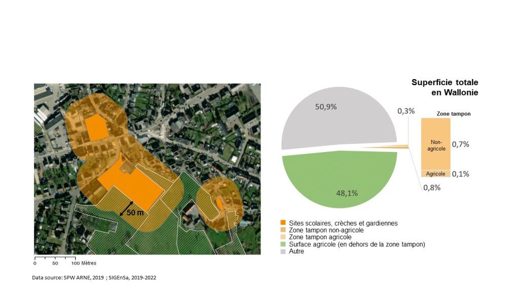
Data source: SPW ARNE, 2019; SIGEnSa, 2019-2022
| ISSeP project leader: Sarah HABRAN | Financed by: SPW ARNE |
| Contact: s.habran@issep.be | Partners: SPW ARNE – CRA-W – CORDER |
| Duration: 2023-2027 |